 The following shows the different types of temperature inversions and how
they form. They are all found in the Southern California area, to varying degrees.
The following shows the different types of temperature inversions and how
they form. They are all found in the Southern California area, to varying degrees.The following shows the different types of temperature inversions and how
they form. They are all found in the Southern California area, to varying degrees.
 The infrared radiation emitted by the ground at night represents a loss of
heat and a subsequent loss of temperature. The air in contact with the ground
then loses heat by conduction to the ground, and ends up being cooler than
the air above, which is not losing temperature as fast because air is a
poor conductor, which then leads to the configuration of warm air overlying
cold air, a temperature inversion (the air temperature increases with increasing
altitude).
The infrared radiation emitted by the ground at night represents a loss of
heat and a subsequent loss of temperature. The air in contact with the ground
then loses heat by conduction to the ground, and ends up being cooler than
the air above, which is not losing temperature as fast because air is a
poor conductor, which then leads to the configuration of warm air overlying
cold air, a temperature inversion (the air temperature increases with increasing
altitude).
Because the effect of heat conduction that cools the air acts only in the thin layer of air next to the ground, this inversion is shallow and is often seen as a ground fog or a thin layer of haze next to the ground.
After the sun heats the ground during the daytime, the air next to the
ground heats up and the radiation inversion is destroyed.
 Cold marine air flows inland due to the sea breeze. The higher density cold
air flows underneath the warmer inland air, forming the inversion configuration
(warm air over cold air).
Cold marine air flows inland due to the sea breeze. The higher density cold
air flows underneath the warmer inland air, forming the inversion configuration
(warm air over cold air).
Note how the cold air forms a wedge as it pushes inland. Pollution emitted
at the ground is advected inland into the wedge by the sea breeze (thus ventilating
the coastal area) and the shallowness of the wedge concentrates the pollutants
(low mixing height). Inland receptor areas
are then inundated by pollution.
 High surface pressure over the Great Basin to the northeast of Southern California
produces an offshore flow of air that starts at a relatively high elevation
inland, and blows down into lower elevations at the coast. The air is being
adiabatically compressed on its way down to the coastline, warming it up (the
Santa Ana Wind).
High surface pressure over the Great Basin to the northeast of Southern California
produces an offshore flow of air that starts at a relatively high elevation
inland, and blows down into lower elevations at the coast. The air is being
adiabatically compressed on its way down to the coastline, warming it up (the
Santa Ana Wind).
When the offshore flow weakens, it does not blow all the way down to the surface
in the coastal regions. The air "heated" by compression stays aloft,
and cold marine air remains at the surface, producing an inversion over the
Southern California region. The mixing heights can
be fairly low in this condition, and the lack of clouds (and accompanying hot
weather) helps produce high ozone levels.
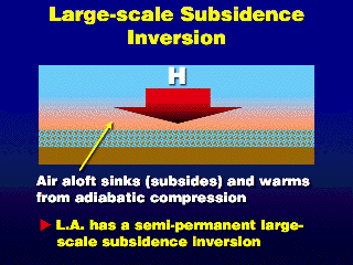 The large-scale subsidence inversion is the semi-permanent temperature
inversion aloft in the Los Angeles area that we often talk about. Climatologically,
there is a semi-permanent high pressure cell, the Eastern Pacific High,
that dominates the west coast of California. In the region under a high pressure
center, air generally sinks. This widespread sinking over Southern California
produces an inversion aloft just like the Santa Ana or Regional Subsidence Inversion
above, only over a larger area, and it persists from day-to-day, while the regional
subsidence inversion usually only lasts a few days.
The large-scale subsidence inversion is the semi-permanent temperature
inversion aloft in the Los Angeles area that we often talk about. Climatologically,
there is a semi-permanent high pressure cell, the Eastern Pacific High,
that dominates the west coast of California. In the region under a high pressure
center, air generally sinks. This widespread sinking over Southern California
produces an inversion aloft just like the Santa Ana or Regional Subsidence Inversion
above, only over a larger area, and it persists from day-to-day, while the regional
subsidence inversion usually only lasts a few days.
![]()
![]()
![]()