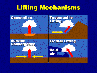
 Cloud formation results from rising air. The mechanisms depicted here
are the main processes by which air rises or is forced to rise.
Cloud formation results from rising air. The mechanisms depicted here
are the main processes by which air rises or is forced to rise.Cloud formation results from rising air. The mechanisms depicted here
are the main processes by which air rises or is forced to rise.
Convection (or free convection) occurs when hot, positively buoyant parcels simply rise through the atmosphere. The air may be "positively" buoyant (a buoyancy force acts to push the air upward, because it is warmer than the environmental air surrounding it) because it was heated at the ground by conduction or it may have originated as a disturbed air parcel in an unstable atmosphere . This process can be superimposed on the other three forced lifting mechanisms shown here.
Topographic lifting, where the wind forces air up the side of a mountain, is also called orographic lifting. For this to be effective, the LCL must be below the top of the mountain ridge. This type of forced lifting enhances the cloudiness and amount of precipitation over the foothills near the mountain (or can cause a deficit of precipitation, called a rain shadow, on the other side of the mountain).
Surface convergence occurs when air moves together toward a single point at the ground. Since the air squeezing together can't go down into the ground, it is forced upward. This occurs in the center of low pressure areas, where the wind slowly spirals into a low at the ground. The lifting is enhanced by convection if the air is positively buoyant or the atmosphere is unstable.
Frontal lifting occurs at
the interface between two air masses of different temperatures. At a cold front,
illustrated here, a mass of cold air blows against a mass of warm air and wedges
underneath the warm air because the cold air is more dense. The warm air mass
is lifted upward by this process, which can produce clouds along the frontal
line if the warm air is sufficiently moist.
![]()
![]()
![]()