 Up to now, we've been evalutating the stability of the atmosphere and the
subsequent behavior of perturbed parcels by starting with an air parcel at the
ssame temperature as the environment. In real life, it is possible for an air
parcel to start off not in equilibrium;
i.e., it will initially be positively
or negatively bouyant. This parcel is NOT "unstable" if it is
positively buoyant, nor is it called "stable" if it is negatively
buoyant, since it will sink if negatively buoyant, and something that is "stable"
would tend to stay put. A classic example of this is an air parcel forming over
blacktop (which gets very hot under the sun) surrounded by white sand, which
does not get as hot as the blacktop. The air parcel over the blacktop is positively
buoyant compared to the rest of the environment, not because the environment
is unstable, and not because the parcel is "unstable", but because
the parcel is positively buoyant.
Up to now, we've been evalutating the stability of the atmosphere and the
subsequent behavior of perturbed parcels by starting with an air parcel at the
ssame temperature as the environment. In real life, it is possible for an air
parcel to start off not in equilibrium;
i.e., it will initially be positively
or negatively bouyant. This parcel is NOT "unstable" if it is
positively buoyant, nor is it called "stable" if it is negatively
buoyant, since it will sink if negatively buoyant, and something that is "stable"
would tend to stay put. A classic example of this is an air parcel forming over
blacktop (which gets very hot under the sun) surrounded by white sand, which
does not get as hot as the blacktop. The air parcel over the blacktop is positively
buoyant compared to the rest of the environment, not because the environment
is unstable, and not because the parcel is "unstable", but because
the parcel is positively buoyant.
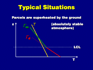
In this example illustrated here,
the atmosphere is stable, based on the slopes of the environmental temperature
profile (the red line) and the adiabats (the red and green lines). Suppose the
parcel at the ground was heated up relative to the surrounding air, as illustrated
in the diagram. Now that it is positively buoyant, it will rise freely (as in
the convection mechanism of cloud
formation). Because of the difference between the environmental
and adiabatic lapse rates, the parcel temperature and environmental temperature
will converge while the parcel rises. Eventually, the parcel stops rising when
it reaches the level of neutral buoyancy, when the two temperatures coincide
(the lines cross). This is how a stable atmosphere suppresses the vertical motion
of positively buoyant air parcels.
In the example illustrated here,
the parcel happens to reach its lifting
condensation level before it becomes neutrally buoyant. We switch lapse
rates because the parcel is now saturated; the parcel keeps rising since it
is still positively buoyant. Because the atmosphere in this example is absolutely
stable, the parcel still stops rising after a while--ending at a higher altitude
than if it stayed unsaturated (follow the dashed red temperature trajectory).
 Suppose we heat atmosphere at the ground to higher temperatures, such as in
the upper plot of this diagram. Re-plotting the environmental temperature profile
in the region where the air was superheated (by the ground, usually) results
in a line that is sloped very much to the left, signifying an unstable region
of atmosphere. Heating the atmosphere at the ground makes the atmosphere less
stable.
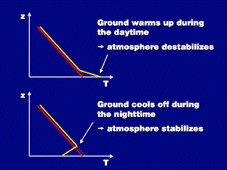
Suppose we heat atmosphere at the ground to higher temperatures, such as in
the upper plot of this diagram. Re-plotting the environmental temperature profile
in the region where the air was superheated (by the ground, usually) results
in a line that is sloped very much to the left, signifying an unstable region
of atmosphere. Heating the atmosphere at the ground makes the atmosphere less
stable.
This means that frequently, the atmosphere
becomes less stable during the daytime, particularly in the afternoon, when
the ground temperature is highest. In the Midwest, summers are often characterized
by the formation of tall thunderstorms due to convection that occurs when the
atmosphere becomes unstable.
In the lower diagram, the air at
the ground is cooled (as it might be at night, due to radiative cooling of the
ground). This results in a shallow temperature inversion (if at night, a nocturnal
radiation inversion), which is absolutely stable. Cooling the atmosphere
from below (or at the ground) results in a more stable atmosphere.